
Escalating flood threat as torrential rain returns to Central Florida
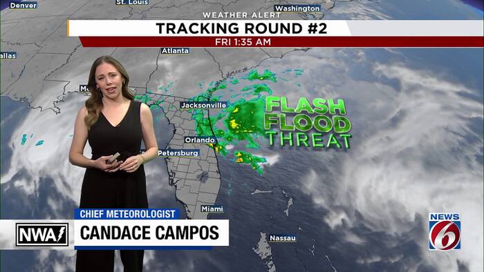
The flooding threat is far from over. Another round of heavy rain is moving into Central Florida Friday morning, putting already flooded and saturated areas at risk for even more dangerous conditions.
The greatest concern today is along the Space Coast and in Volusia County, where the potential for flash flooding is high.
A Flood Watch remains in effect through this evening. The News6 Weather Team is continuing to highlight the serious flooding threat, especially across Brevard and Volusia counties, where the heaviest additional rainfall is expected.
Another round of rain
Rain bands continue pushing onshore this morning, with the strongest activity near the central and northern Brevard coast.
Through Saturday, another 2 to 4 inches of rain is possible across much of the area, with the highest totals expected across Brevard and Volusia counties.
Coastal communities in those counties could see another 4 to 8 inches, with pockets of higher amounts.
Another round of heavy rain could intensify the flooding threat, with downpours falling on already saturated ground and worsening ongoing flooding.
The Weather Prediction Center has placed the Space Coast and Volusia County under a High Risk, Level 4 out of 4, for excessive rainfall today. That’s the highest risk level. Slight to Moderate risks, Levels 2 and 3, extend across the interior.
The primary concern over the next 24 to 48 hours is locally heavy rainfall and dangerous flash flooding.
St. Johns River on the rise
Extensive flooding continues along the St. Johns River following exceptional rainfall across the upper reaches of the river basin in recent weeks.
The river near Cocoa recently climbed to 18.48 feet, breaking the previous record set in 1953. Additional heavy rainfall is expected to push river levels higher into the weekend, early next week and potentially beyond.
Even as rain chances decrease this weekend, river flooding will remain a concern through most of December.
Wind advisory issued
Northeast winds will increase today, especially along the Volusia coast and northern Brevard County. Sustained winds of 15 to 25 mph with gusts of 35 to 40 mph are possible in those areas.
A Wind Advisory is in effect for coastal Volusia and northern Brevard through 7 a.m. Saturday.
Weekend outlook
Rain chances should drop to 20% to 50% Saturday as the low-pressure system moves north.
Drier conditions are expected Sunday into Monday, with a few showers potentially returning Tuesday and Wednesday.